Digital Pollinator Survey & Biodiversity Monitoring Platform – NBDC

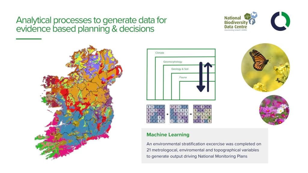
The National Biodiversity Data Centre (NBDC) is Ireland’s national hub for biodiversity data. Established by the Heritage Council, it collects, analyses, and shares vital information on Ireland’s wildlife and habitats, helping to support conservation, research, and environmental decision-making.


Client Requirement

One of the NBDC’s key initiatives was the Protecting Farmland Pollinators project, funded through the European Innovation Partnership (EIP) and delivered as part of the All-Ireland Pollinator Plan. The project encouraged farmers to adopt simple, practical measures that support biodiversity alongside productive farming, with participants receiving financial incentives for their efforts.

To support the programme, Compass Informatics developed a comprehensive digital platform that brought together cloud computing, GIS technology, and mobile applications. The solution delivered allows the NBDC to efficiently manage the project, monitor biodiversity actions, and engage with participating farmers across Ireland.

The Platform Needed To:

  1. Enable farmers to easily record and manage biodiversity actions through web and mobile applications.
  2. Capture and map habitat data using GIS technology for monitoring and verification.
  3. Streamline programme administration, participant management, and payment processes.
  4. Provide real-time reporting and insights to support decision-making and project evaluation.
  5. Deliver a secure, scalable cloud-based solution capable of supporting programme growth.

The Solution – Digital Pollinator Survey and Scorecard Platform

Compass Informatics a cloud-based solution that simplifies habitat assessment, farmer participation, and programme administration for the Protecting Farmland Pollinators initiative.

The platform combines mobile, web, and GIS technologies into a single, user-friendly system, enabling farmers to map farm boundaries, complete habitat surveys, upload photographic evidence, and submit claims from the field or office. Built on the client’s existing ArcGIS environment, the solution uses automated spatial analysis and scoring to deliver accurate, real-time assessment results.

Designed for rural environments, the mobile application supports offline data capture on both iOS and Android devices, ensuring reliable field data collection regardless of connectivity. Automated workflows streamline application processing, scorecard generation, and reporting, significantly reducing administrative effort.

A real-time management dashboard provides programme administrators with complete visibility of submissions, habitat actions, scores, and verification data, creating a more efficient and scalable approach to biodiversity monitoring and scheme management.

Digital Pollinator Survey

The Key Benefits Delivered

  • Provided farmers with a simple, user-friendly digital platform to map, monitor, and understand pollinator habitats using integrated GIS tools
  • Enabled active participation in biodiversity conservation while supporting financial incentives for pollinator-friendly actions
  • Increased the quality, consistency, and volume of environmental and habitat data collected across the scheme
  • Significantly reduced administrative burden for the NBDC through streamlined, automated digital workflows and improved scheme management
  • Improved farmer engagement and awareness of pollinator protection and sustainable land management practices
  • Delivered a cost-effective, cloud-based solution accessible from any device, ensuring ease of use and scalability for all stakeholders

Growing Impact, Lasting Change

The Digital Pollinator Survey Platform has transformed how pollinator habitats are recorded, managed, and supported across farmland. By combining ease of use with powerful GIS and cloud-based technology, it has improved data quality, reduced administrative effort, and strengthened farmer engagement in biodiversity protection. The result is a scalable, cost-effective solution that not only supports environmental goals today but also helps build more sustainable farming practices for the future.

About Compass

Compass Informatics is an Irish company providing location technologies and data analytics solutions which enable government and commercial organisations to deliver more efficient operations, protect their assets and meet regulatory requirements.

Compass Informatics’ services include GIS & Data Analytics, IT Systems Development and Location Technologies and the company has won awards for their innovative solutions and focus on sustainability.

Compass leverages the latest technologies to achieve full-service project delivery including; Big Data Analytics, AI, Cloud, Mobile, GIS and Satellite-based Earth Observation amongst others.

Compass Informatics  are part of Tracsis Plc.

LinkedIn | Website

To learn more about this project, and how the solution provided may benefit your organisation, please contact our government solutions team at info@compassinformatics.com.