
Find out how we delivered the first fully verified, high-fidelity geospatial inventory of Northern Ireland’s entire bus network, transforming Translink from outdated, inconsistent records to a modern, data-driven operational model. Covering 13,499 bus stops across 14,130 km².

Client Challenge
Translink faced significant operational and compliance challenges due to an outdated and unreliable spatial dataset underpinning its extensive bus stop and shelter network. Our team supported the modernisation of these infrastructure records through a large-scale, national survey to fully audit and characterise every stop and shelter.
The project was complex due to several underlying issues:
- Logistical inefficiencies caused by inaccurate or incomplete location data that hindered effective route planning and network optimisation
- Long‑standing maintenance backlogs resulting from inconsistent records that obscured the true condition and upgrade requirements of stops and shelters
- Substantial compliance and accessibility gaps due to the absence of reliable statistics on critical infrastructure attributes, such as the number of wheelchair‑accessible stops required for regulatory reporting

Building a Standardised, Scalable Framework for Network-Wide Data Collection
To meet these challenges, Translink needed a streamlined, standardised and highly accurate approach to data collection that could be applied consistently across the entire network.
Our team was therefore engaged not only to conduct the nationwide audit but also to design and implement the methodological, technical and analytical framework necessary to ensure that the resulting dataset would be robust, verifiable and operationally valuable. The solution needed to combine rigorous field data collection with a scalable, cloud-connected GIS architecture – capable of covering 14,130 km² efficiently and accurately.

Integrated Digital Workflow for National-Scale Infrastructure Audit
Compass Informatics built a complete digital system for Translink’s nationwide infrastructure audit, replacing scattered legacy data with one integrated, reliable cloud platform powered by ArcGIS Online Field Maps.
Built-in accuracy checks, real-time sync, and daily validation – quality control at every step, across all 14,000 assets.
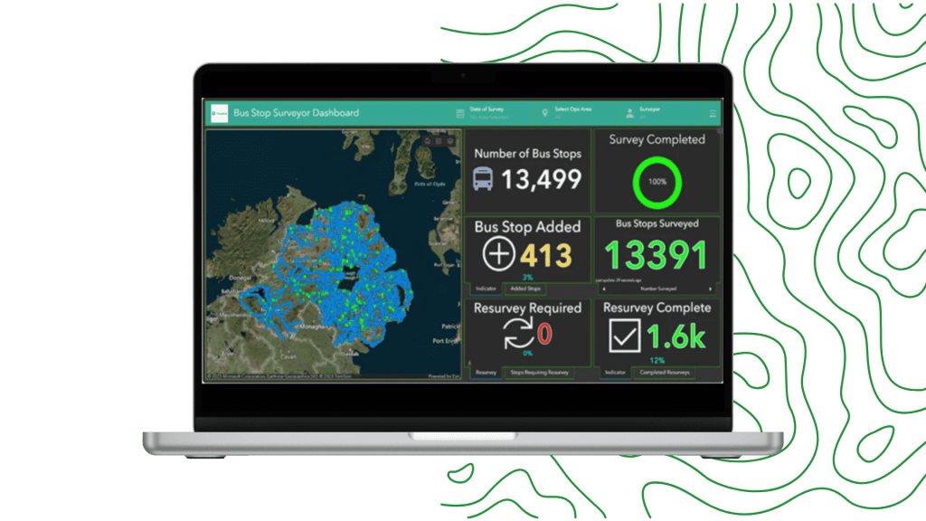
Translink stakeholders now have access to a live dashboard showing survey progress in real time. They can filter results by region, date, or surveyor, and pull out insights for maintenance planning before the fieldwork even wrapped up. This gives the whole team one clear, trusted source of information, cutting out data silos, speeding up decisions, and keeping everyone in the loop throughout the project.
Solution Benefits
- Delivered the first fully verified, high-fidelity geospatial inventory of Northern Ireland’s entire bus network.
- Validated 13,499 bus stops with 100% network coverage, confirming geospatial accuracy and correcting long-standing location errors.
- Uncovered and integrated 413 previously unmapped stops, creating the first definitive national dataset.
- Delivered a fully attributed GIS dataset, including a comprehensive photographic library of 35,000 images.
- Engineered for seamless integration into Translink’s enterprise systems, enabling immediate use across maintenance, scheduling, reporting, and strategic planning.
- Reduced operational risk and supported mandatory accessibility reporting with a single, reliable source of truth.
- Provided the evidence base required for network-wide upgrades and future route planning decisions.
As a result of this project, we have been provided with a high-quality data source that will enhance our customer experience and shape future network planning decisions
Our Partnership Gives You Access to a Network of Expertise and Solutions
By partnering with Tracsis Group entities such as Tracsis Geo Intelligence clients gain access to a broad and complementary portfolio of leading solutions, spanning operations analytics, asset management, digital rail technology, geospatial intelligence and data analytics. Tracsis Geo Intelligence is operated by Compass Informatics UK Ltd, a UK-registered company.
Get in touch
For more information on our solutions or how we can support your project objectives, get in touch with a member of our team. All inquiries are handled with the utmost discretion.