BusConnects Dublin – NTA

BusConnects Dublin is a major investment programme to improve public transport in the city, with a focus on increased efficiency and reliability.

Compass Informatics’ role was to provide a visualisation and route planning tool to illustrate how the changes would impact journeys and generate public discussion.

About The NTA

The National Transport Authority or NTA is the transport authority for Greater Dublin and the public transport licensing agency for Ireland.

The NTA took over certain functions from the Department of Transport and the entire role of the Dublin Transportation Office.

The NTA operates under the consumer facing brand Transport for Ireland.

Project Requirement

In advance of the second phase of public consultation for the Bus Connects Dublin (BCD) project, the National Transport Authority (NTA) identified the need for an online tool.

The tool must allow members of the public to visualise how the new BCD network will facilitate their day-to-day travel.

It also needed to be reliable and robust to accommodate high volumes of requests, cost effective and easy to use.

Compass’ Solution – BusConnects Dublin Route Mapper

The Route Mapper relies upon Open Street Map (OSM) as the underlying base data in the application, combined with Open Trip Planner and the NTA’s proprietary GTFS data.

  • OSM is a reliable and cost-effective mapping platform which can be used for web applications.
  • The GTFS Dataset is the proprietary NTA data relating to different transport options available, bus stops and timetables. 

OpenTripPlanner (OTP) is a family of open source software that provides passenger information and transportation network analysis services.

The component finds itineraries combining transit, pedestrian, bicycle, and car segments through networks built from widely available, open standard OSM and GTFS data.

Routing parameters are configured to represent the proposed network and service schedules.

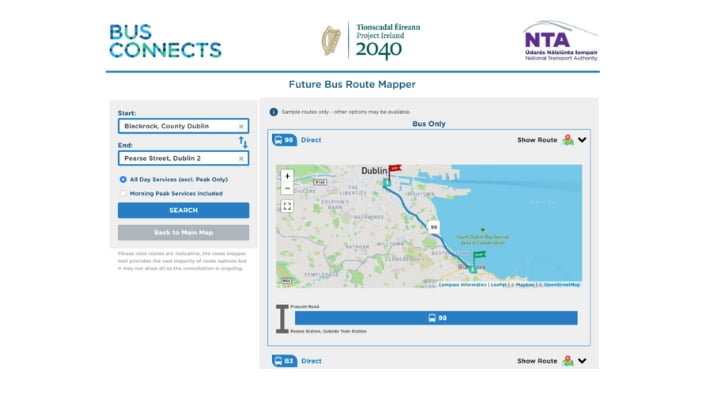
The search function can allow up to 3 route options, where available:

  1. A direct bus route
  2. The fastest bus only option regardless of number of interchanges
  3. The fastest bus & rail option with at least 1 rail leg (Dart, Luas, rail)

The User Interface enables the user to search for their starting location using:

  • My location
  • Plate code (the unique identifier on bus stops in the Dublin area)
  • Address
  • Eircode
  • Place name

The search function is restricted to a distance of 3000m from the Dublin Bus Network, with an error notification if users try to select areas that are not in range.

Solution Snapshot

Route Mapper User Interface.

About Compass

Compass Informatics is an Irish company providing location technologies and data analytics solutions which enable government and commercial organisations to deliver more efficient operations, protect their assets and meet regulatory requirements.   

Compass Informatics’ services include GIS & Data Analytics, IT Systems Development and Location Technologies and the company has won awards for their innovative solutions and focus on sustainability.

Compass leverages the latest technologies to achieve full-service project delivery including; Big Data Analytics, AI, Cloud, Mobile, GIS and Satellite-based Earth Observation amongst others. 

Compass Informatics  are part of Tracsis Plc.

LinkedIn | Website

To learn more about this project, and how the solution provided may benefit your organisation, please contact our government solutions team at info@compassinformatics.com.