HubCAP – ESA InCubed Programme

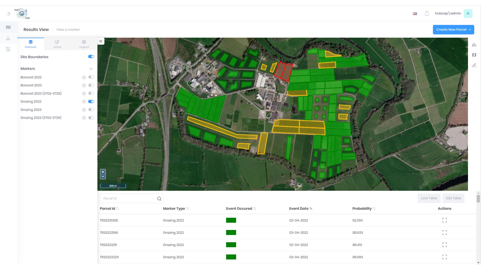
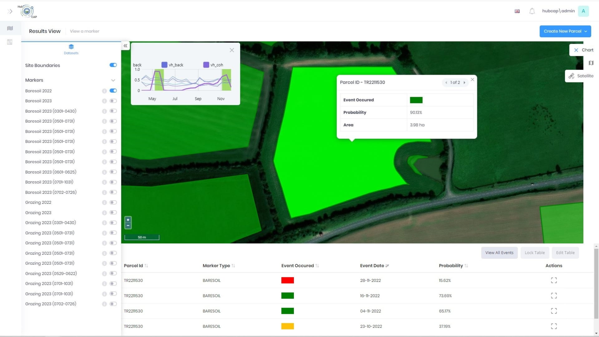
HubCAP is a project run in partnership with the ESA InCubed programme, with the aim to build a platform and service that facilitates the use of satellite imagery for automated assessment of land use and land use change across multiple domains. 

Specifically, the intention is to address the needs of three distinct sectors with overlapping requirements:

  • Large Paying Agencies – National and regional agencies administering CAP subsidy payments that require validation of the area claims submitted by farmers.
  • Smaller Public Agencies – Involved in land monitoring or administration of Green Deal or other legislative objectives such as European Agricultural Fund for Rural Development, that require claim validation or on-the-ground monitoring. ​
  • Private sector – Entities from public and private sector that require assessment and validation of land management assets – including financial services, transport, environmental and agriculture.

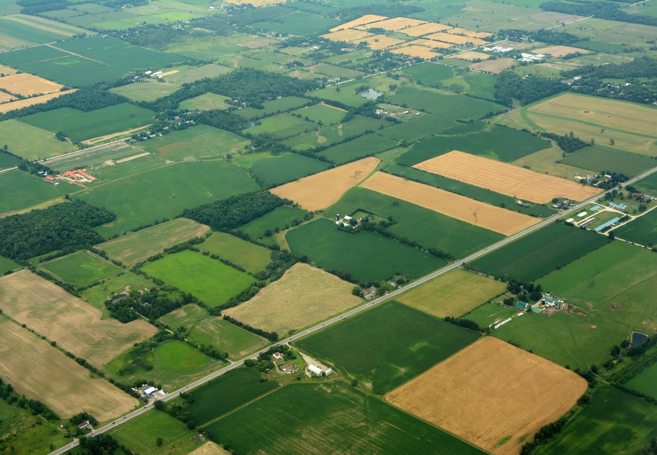
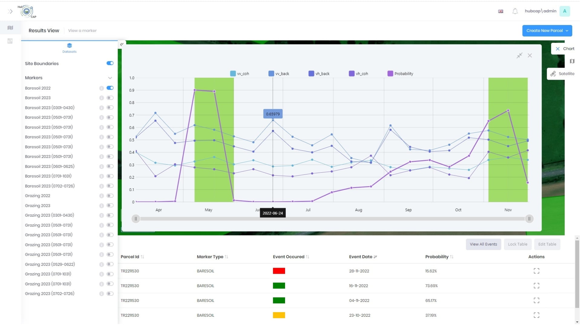
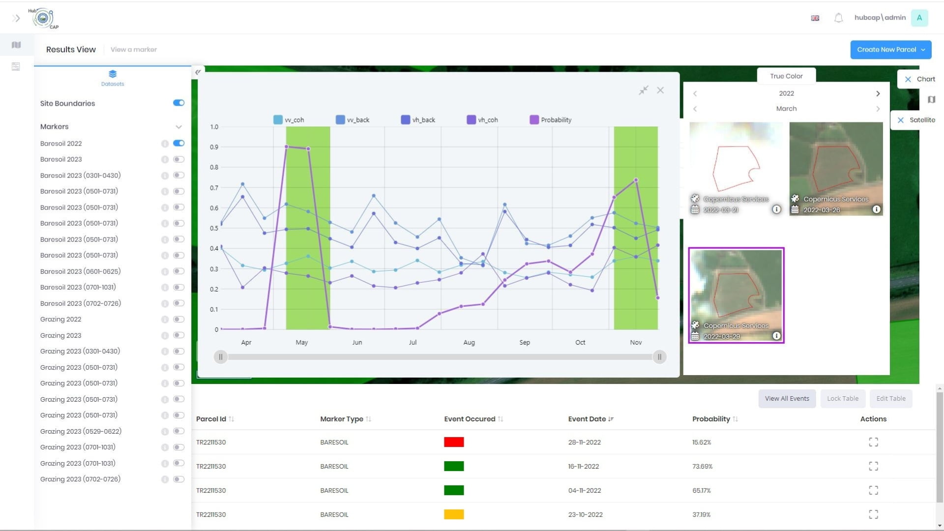
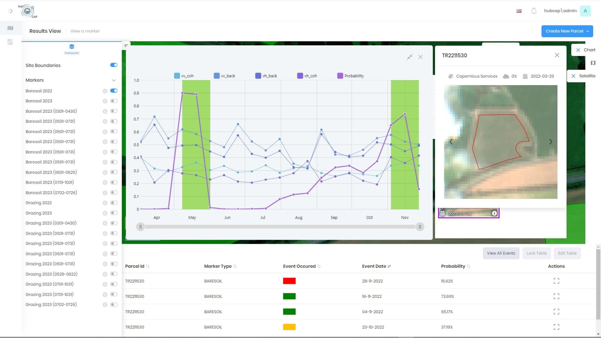
Historically, monitoring and assessment in these domains has been delivered through on the ground validation or manual inspection of satellite imagery. 

This is time-consuming and costly and replacing these manual processes with periodic or continuous ‘monitoring’ using Sentinel imagery could reduce the use of on-the-ground visits.

About HubCAP – ESA InCubed

The European Space Agency (ESA) is Europe’s gateway to space and its mission is to shape the development of Europe’s space capability, to ensure that investment in space continues to deliver benefits to the citizens of Europe and the world.

The InCubed program focuses on developing innovative and commercially viable products and services that generate or exploit the value of Earth Observation imagery and datasets.

The HubCAP solution is a set of services and a platform with the flexibility to consume a variety of EO data sources and to allow the assessment through any algorithm that has been added to the platform. 

It can be accessed directly through the platform or through a comprehensive API for monitoring via direct integration with existing administration systems.

This allows for bespoke ad-hoc local analyses that can be conducted by non-expert users who can define areas to be assessed and the assessments to be carried out, and viewing results, thus freeing up skilled technicians for higher-value activities.

Project Requirements


The process of validating and reviewing land use and land use change in agriculture has been a process of visiting fields to validate any claims made, an activity which is very time consuming.

The objective of HubCAP is to give non-technical users the ability to initiate and view land use and land use change in a wide variety of scenarios. 

This requires the ability to automatically detect, without human interaction, if an event has occurred and the changes in land use over time and display this in the map view.

This will aid in the process of validating financial claims, review land use and land use change more efficiently.

Compass’ Solution

This leverages the power of Sentinel 1 (Radar) and Sentinel 2 (Optical), whilst outputs of monitoring and assessment can be interrogated through the front end.

Processes run on schedule or on demand for any new parcels or imagery available. 

Configuration, queuing and orchestration for each process, and thresholds seen within the front end of the platform can be configured within the platform itself.

A scheduler checks if new imagery is available if new parcels are created or uploaded and will kick off the necessary processing scripts to return this data to the front end. 

Given the long duration of EO assessment execution, a monitoring agent tracks and manages processes as required to ensure they run to completion.

Marker Processing
  • The marker processing engine takes the parcel boundary and a date range, downloading the sentinel 1 imagery needed for those boundaries and dates.
  • The required signals (VV, VH, SLC) are produced across the geographic extent of the parcels. 
  • Statistics are then calculated for each parcel and marker assessment is run against the boundaries using these values. 
  • Data returned will be a probability percentage for each available sentinel 1 date, which is then used to determine if an interesting event has occurred. 
Image Processing
  • The visible image processing chain takes the boundary and a date range, downloading the available sentinel 2 true colour imagery needed for those boundaries and dates.
  • Imagery is cropped to size for each parcel, for each date and layering the boundary back over the imagery.
  • The resulting images are then available to view in the from end when you select on a parcel, which allows for visual validation of the on-the-ground changes detected by the markers.

As well as the automatic processing against the markers, the outputs and data are also visible in the front end. The RAG values are visible when you turn on a maker on in the layer list within the front end.

The individual probabilities and RAG value for each available date is also visible in the attribute table, with the signals data used from each sentinel 1 date also viewed in the chart widget for each marker. 

Solution Benefits

  • Automated processing provided by the HubCAP platform replaces much of the manual work with making assessments of land use and change over time.
  • Results can be validated quickly using the images in the UI to give confidence in the decisions made.
  • New areas for assessment can be created or uploaded and have results for these areas in a short period of time as well as continuous monitoring of previously created parcels.
  • As assessments are automatically run when new data is available, it is not necessary to manually kick off any processes to get new data, therefore you have data when you need it.
  • Attribute table & charts allows data to drive the decisions being made, as well as being able to change the thresholds applied and see instant results.
  • The UI can be used for orchestration and control, but this is not necessary.  3rd party systems can integrate directly against the services to invoke the processing chains against selected land parcels.

Solution Snapshots

About Compass

Compass Informatics is an Irish company providing location technologies and data analytics solutions which enable government and commercial organisations to deliver more efficient operations, protect their assets and meet regulatory requirements.

Compass Informatics’ services include GIS & Data Analytics, IT Systems Development and Location Technologies and the company has won awards for their innovative solutions and focus on sustainability.

Compass leverages the latest technologies to achieve full-service project delivery including; Big Data Analytics, AI, Cloud, Mobile, GIS and Satellite-based Earth Observation amongst others.

Compass Informatics  are part of Tracsis Plc.

LinkedIn | Website

To learn more about this project, and how the solution provided may benefit your organisation, please contact our team at info@compassinformatics.com.