
Green Meridian Information Factory for UK-Ireland-France: Final Showcase
Join us for our final GTIF Green Meridian event showcasing our final project deliverables!
Compass Informatics is excited to showcase the key achievements and deliverables from this innovative project, developed in collaboration with UCL, Earth Daily Analytics, and Surrey AI Imaging Ltd. Bringing together experts, innovators, and decision-makers, the GTIF Green Meridian project explores how geospatial technologies and advanced analytics are reshaping industries from public sector and environment to infrastructure and transport.
This free hybrid interactive session will provide an opportunity for the GMif team members to present the tools, resources, and outputs developed throughout the project, all designed with your requirements as stakeholders in mind. We are keen to demonstrate the products in an engaging format, allowing you to explore their practical applications and discuss how they can support your work.
Our goal is that these deliverables will help accelerate the green transition by equipping stakeholders with actionable insights, innovative solutions, and collaborative opportunities. Your perspective is central to this, and we very much value your engagement.
What is GTIF?
The Power of Earth Observation for Sustainability
The global climate crisis demands immediate action. Transitioning societies and economies towards carbon neutrality requires a multi-faceted approach encompassing policy, innovation, and a sustainable relationship with our planet’s resources.
The ESA GTIF project tackles this challenge head-on by harnessing the power of Earth Observation (EO) data.
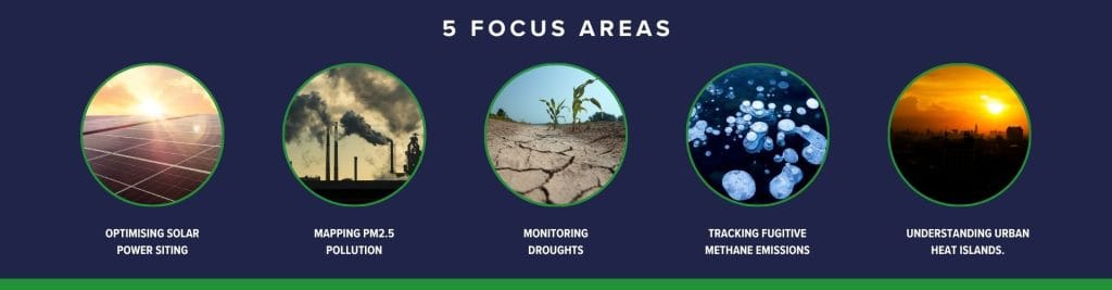
This innovative project focuses on the UK, Ireland, and France. Compass Informatics will be focusing on five key areas crucial for this Green Transition:
This GTIF demonstration project, funded by the European Space Agency (ESA), has developed a rich, web-based geospatial information system (webGIS) covering the land areas of the UK, Ireland, and France. The webGIS supports a wide range of stakeholders:
- Urban planners identifying temperature hot-spots and sources of atmospheric pollution (PM2.5)
- Green transition planners developing large rural solar farms while avoiding environmentally sensitive areas
- Farmers, NGOs, and local communities monitoring long-term drought predictions for croplands
- Global monitoring of large-scale natural and unplanned methane emissions
This project is part of the ESA “Green Transition Information Factories” (GTIF) initiative, aiming to deliver tools and capabilities that drive sustainable land use and informed decision-making.
Join us to see the results and learn how geospatial innovation is shaping a greener, smarter future.
Event Details
- Date: 21st April 2026
- Time: 11:00am – 16:00pm
- Location: University College London
- In-Person Registration: Click here.
- Attend Online: Click here.
What You’ll Learn
-
How GIS and geospatial analytics drive smarter decision-making
-
Real-world applications across government, infrastructure, and sustainability
-
How Earth Observation data is enabling new insights and efficiencies
-
Practical approaches to turning legacy data into strategic value
-
Emerging trends in data, AI, and spatial intelligence
Why Attend
Learn from Industry Experts
Hear directly from specialists working at the forefront of geospatial innovation.
Real-World Use Cases
Discover how organisations are already using data to improve outcomes and efficiency.
Networking Opportunities
Connect with peers, partners, and industry leaders in a collaborative setting.
Actionable Insights
Leave with practical ideas you can apply immediately within your organisation.
About Compass Informatics
Compass Informatics is a leading provider of GIS, Earth Observation, and data analytics solutions, helping organisations unlock the full value of their data.
With expertise spanning software development, spatial analysis, and cloud technologies, Compass delivers solutions that support smarter planning, better decision-making, and sustainable outcomes.