Area Monitoring System (AMS) – DAFM

The Department of Agriculture, Food and the Marine (DAFM) is the government department in Ireland responsible for agriculture, food production, forestry, and rural development.

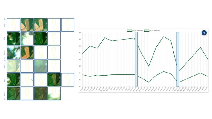
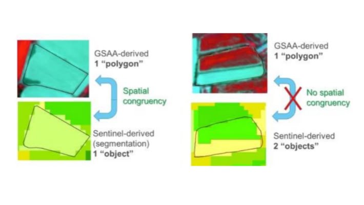
DAFM have traditionally used satellite imagery to validate farmer land-use claims but from 2023 have sought to modernise and extend claim validation though automated land-cover ‘monitoring’. 

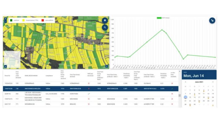
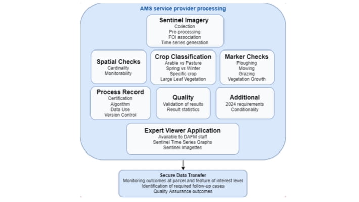
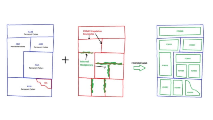
Based on workflows required an Area Monitoring System (AMS) to monitor and assess agricultural activities and provide a reliable determination of compliance with various land-based CAP intervention schemes. 

The AMS implementation offers many benefits, including, extended monitoring, reduced on-farm inspections, warning alerts to farmers to minimise non-compliance, and the ability for farmers to make necessary changes to ensure compliance and avoid penalties.

About DAFM

The Department of Agriculture, Food and the Marine (DAFM) is the government department in Ireland with responsibility for agriculture. 

DAFM’s role is to support and develop the agricultural and food sectors, ensuring their sustainability and competitiveness. 

DAFM is a statutory EU ‘Paying Agency’ and tasked with the administration of EU CAP subsidy payments to farmers in Ireland. 

They are extensive users of Geographic Information Systems (GIS) and Earth Observation technologies (EO).

Project Requirements

Through detailed engagement in 2022, DAFM described the need for an advanced land cover monitoring platform, ‘Area Monitoring System’ (AMS), to meet their statutory CAP compliance needs and objectives. 

The system required would fulfil the following requirements:

  • Compliance Verification
  • Universal Monitoring
  • Timelines
  • Sub-Parcel Level Monitoring
  • Bespoke Algorithms
  • Integration with LPIS
  • Spatial Checks
  • Crop Classification
  • Marker Identification
  • Interface:
  • Traceability and Quality Control
  • Expert Viewer App

These requirements aimed to ensure that the Area Monitoring System meets the needs of DAFM by offering comprehensive, automated, and accurate monitoring of land cover and seasonal agricultural activities.

Compass’ Solution – Area Monitoring System (AMS)

Compass developed a comprehensive AMS solution to meet the specific requirements identified by DAFM. 

The monitoring platform delivered has significantly enhanced CAP compliance verification capabilities and now represents the basis for all CAP payments in Ireland.

The solution provided offers DAFM a universal monitoring capability, allowing checks to be extended to cover 100% of land parcels in the Republic of Ireland, while significantly reducing the need for costly VHR imagery and On-The-Spot-Checks (OTSC).

AMS also incorporates bespoke time-series algorithms which intermittently assess all land parcels, recording change over time and reporting upon individual claimable FOI areas to IACS, the departments payment administration platform.

Solution Benefit

AMS permits DAFM to reliably account for the disbursement of €1.5B in subsidy payments to Irish farmers each year, but it also provides a number of soft benefits:

  • Accurate and Timely Monitoring – by leveraging Sentinel satellites, AMS  enables accurate and timely monitoring of agricultural activities and land cover, providing DAFM with valuable land use insight and the ability to verify farmer payment claims.
  • Cost-Effective Solution – AMS derives particular benefit from the utilisation of freely available data from the Sentinel satellites, substantially reducing the need for costly commercial VHR imagery.
  • Objective and Transparent Decision-Making – the technology utilised for image processing, analysis and change detection reduces reliance on manual interpretation, leading to a more objective, transparent and repeatable determination process.
  • Improved Policy Interventions – through regular universal monitoring, AMS helps DAFM and associated agencies to detect inappropriate land use changes, identify in-compliant practices, and to apply interventions.
  • Enhanced Resource Management – the utilisation of AMS, in combination with VHR imagery and geo-photo apps, has facilitated improved resource management through substantial reductions in OTSC field checks.
  • Improved Sector Visibility – data made available through AMS provides DAFM with valuable insight to agricultural patterns at local and regional level.

Solution Snapshot

Sentinel Time-series image illustrating Permanent Grassland Life-cycle


AMS Expert Viewer App permitting the examination of parcels at feature level


AMS Processing functions


LPIS Parcels subdivided as Features of Interest (FOI) functions


AMS Spatial Cardinality checking for multiple activities within a FOI

About Compass

Compass Informatics is an Irish company providing location technologies and data analytics solutions which enable government and commercial organisations to deliver more efficient operations, protect their assets and meet regulatory requirements.   

Compass Informatics’ services include GIS & Data Analytics, IT Systems Development and Location Technologies and the company has won awards for their innovative solutions and focus on sustainability.

Compass leverages the latest technologies to achieve full-service project delivery including; Big Data Analytics, AI, Cloud, Mobile, GIS and Satellite-based Earth Observation amongst others. 

Compass Informatics  are part of Tracsis Plc.

LinkedIn | Website

To learn more about this project, and how the solution provided may benefit your organisation, please contact our government solutions team at info@compassinformatics.com.