MapRoad PMS – LGMA

The MapRoad PMS project involved the development and implementation of an advanced road pavement management solution for use by local authorities (County Councils) across Ireland. 

The solution was implemented by Compass Informatics on behalf of the Local Government Management Agency (LGMA), who represent Local Authorities, the Road Management Office (RMO) and Department of Transport.

The LGMA had a specific requirement to improve road asset information management practices of local authorities, and to facilitate data-driven decision-making processes related to the investment in the national road network. 

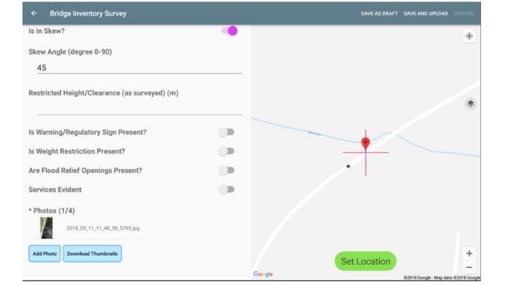
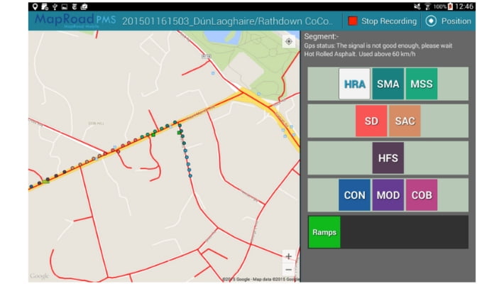
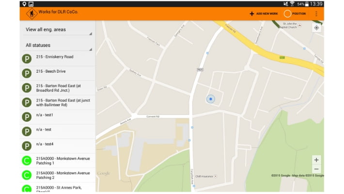
The solution provided comprised an engineering module for analysing pavement condition and planning maintenance activities effectively.

About The LGMA

The Local Government Management Agency (LGMA) is a state agency that provides professional support and services to local authorities, with particular emphasis on providing shared IT solutions. 

Established in 2012, the LGMA work closely with all 31 local authorities to enhance the efficiency of local government operations.

Their activities include the development and maintenance of innovative information systems and technology platforms to streamline data management and enable efficient local government asset management. 

The LGMA’s goal is to drive digital transformation, improve service accessibility, and foster innovation within the local government sector in Ireland.

Project Requirement

The Local Government Management Agency (LGMA), in consultation with Local Authority engineers and the RMO, established a set of specific business and technical requirements which they hoped to achieve through MapRoad PMS platform implementation.

From a business perspective, the LGMA aimed to establish a standardised and coordinated approach to road pavement management across all local authorities in Ireland. 

MapRoad PMS needed to provide a comprehensive map based solution that would enable efficient management of pavement attribute data, survey data, work programs, and historic road works. 

It was crucial for the system to support decision-making processes related to road maintenance funding and to facilitate coordinated strategic planning at both local and national level.

Compass Informatics successfully met all requirements, providing a robust solution for pavement management across Ireland’s local authorities.

Compass’ Solution – MapRoad

MapRoad PMS is a comprehensive solution provided by Compass Informatics for managing road pavement data and related activities across Ireland. 

The solution has been developed over a number of years, with successive phases of expansion, following our standardised implementation process;  requirements gathering, design, development, testing, deployment, and maintenance.

During the requirements gathering phase, Compass Informatics closely worked with the Local Government Management Agency (LGMA), the Road Management Office (RMO), and end users from local authorities.

All Mobile Apps work both online and offline & uploaded data is immediately available in the PMS system due to the development and availability of the web services hosted with the central PMS system.

All App’s were developed within Xamarin’s cross-platform development framework and use Google Maps as background mapping, and leverage the Google Play services for GPS location.

Solution Benefit

The MapRoad PMS solution provided by Compass Informatics has brought numerous benefits to the Local Government Management Agency (LGMA), the Road Management Office (RMO), and to Local Authorities across Ireland, such as;

  • Improved Decision Making
  • Enhanced Asset Management
  • Cost Savings
  • Compliance and Accountability
  • Streamlined Workflows
  • Data Integration and Standardisation
  • Enhanced Data Accuracy and Quality
  • Real-time Monitoring and Reporting
  • GIS Capabilities
  • Scalability and Flexibility 

In short, the MapRoad PMS solution has empowered the LGMA with improved decision-making, streamlined workflows, cost savings, and enhanced road asset management.

Solution Snapshots

MapRoad PMS – Main Graphical User Interface.


MapRoad PMS – Bridge Module Inventory User Interface.


MapRoad SCI App Interface showing capture of field attribute data.


MapRoad Roadworks App Interface showing field data capture.

About Compass

Compass Informatics is an Irish company providing location technologies and data analytics solutions which enable government and commercial organisations to deliver more efficient operations, protect their assets and meet regulatory requirements.   

Compass Informatics’ services include GIS & Data Analytics, IT Systems Development and Location Technologies and the company has won awards for their innovative solutions and focus on sustainability.

Compass leverages the latest technologies to achieve full-service project delivery including; Big Data Analytics, AI, Cloud, Mobile, GIS and Satellite-based Earth Observation amongst others. 

Compass Informatics  are part of Tracsis Plc.

LinkedIn | Website

To learn more about this project, and how the solution provided may benefit your organisation, please contact our government solutions team at info@compassinformatics.com.