

How Compass Informatics Uses GIS to Map, Measure and Maximise Organisational Value
In today’s data-driven world, organisations are sitting on vast amounts of legacy data, rich information that has been collected over years, sometimes decades, but remains under‑utilised, unconnected and difficult to act on.
By analysing, mapping and structuring data, we help organisations define what information is most valuable and create a clear roadmap for informed decision‑making. With our experience across Government & Public Sector, Transport, Construction & Engineering, Agriculture, and Utilities, Compass delivers tailored solutions that support operational efficiency, strategic planning and long‑term transformation.
Why Legacy Data Matters
Many organisations underestimate the potential value in their legacy systems. Data collected for one purpose, asset lists, surveys, inspection records when unlocked, can reveal patterns, risks and opportunities previously hidden in spreadsheets and disparate databases.
Compass specialises in:
- Data Integration & Cleansing — Bringing together siloed datasets into a consistent, interoperable format.
- Value Assessment — Identifying which data layers drive decision‑making and deliver return on investment.
- Spatial Insight — Revealing geographic patterns and relationships that support operational and strategic objectives.
- Roadmap Development — Defining clear short‑, medium‑ and long‑term actions aligned with organisational goals.
Government & Public Sector
Informing Policy with Precision
At Compass, we have helped government agencies digitise legacy land records, standardise service delivery databases, and integrate socio‑economic datasets to support community planning and resource allocation. By mapping these datasets spatially and over time, decision‑makers are able to:
-
Target investment where it’s most needed
-
Monitor service outcomes geographically
-
Improve transparency and reporting
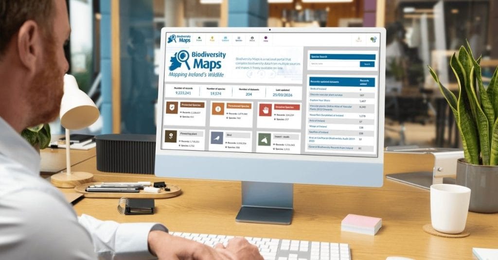
Public sector organisations require accurate, trusted data integrated across departments for planning, regulatory reporting and community services. One high‑impact example of this in action is the upgrade of Biodiversity Maps a national repository of species distribution and environmental data developed by the National Biodiversity Data Centre with support from Compass Informatics.
The upgraded portal brings together over 4 million vetted records of nearly 16,000 species, enabling planners, consultants, local authorities and conservation bodies to interrogate biodiversity data by location, species status or habitat type and generate robust reports that support local planning and environmental assessments.
Transport
Mapping Movement to Improve Mobility
Transport agencies grapple with complex legacy datasets, from historical traffic counts to ageing asset registers and route performance logs. Compass uses GIS to unify these datasets with real‑time feeds, enabling planners to:
-
Identify congestion hotspots
-
Optimise public transport routes
-
Predict maintenance needs
Transport systems generate enormous volumes of data, from traffic counts to travel demand, route performance and infrastructure condition. GIS empowers agencies to bring these datasets together and unlock spatial relationships that inform network planning and optimisation.
A key example is our work on BusConnects Dublin, a major transport investment programme where Compass provided spatial analysis and data visualisation that supported network design and strategic planning.

Construction & Engineering
Data‑Driven Site Intelligence
In construction and civil engineering projects, legacy data including surveys, design records, condition reports and site logs, often exists in fragmented systems. GIS provides a unified spatial context that enables better risk analysis, design insight and project continuity.
Compass helps engineering clients establish spatial frameworks that bring these datasets together, improving visibility across project lifecycles and supporting safer, data‑driven decisions. By harmonising legacy engineering data and visualising it on maps and dashboards, teams can reduce duplication, reduce investigation costs and improve confidence in their planning processes.
Agriculture
From Field Logs to Field‑Level Action
Agricultural data including soil tests, yield records, environmental sensor data and compliance reports, holds enormous potential, but only when it’s structured, integrated and spatially analysed. Legacy datasets scattered across spreadsheets, field notebooks and disparate systems make it difficult to see where and why productivity varies across the landscape. Our GIS and data analytics work helps agribusinesses, government agencies and research consortia transform raw agricultural data into actionable spatial insight that supports planning, sustainability and compliance.
Area Monitoring System for DAFM
In partnership with the Department of Agriculture, Food and the Marine (DAFM), Compass developed the Area Monitoring System, a GIS‑enabled platform that consolidates environmental monitoring, land use and agricultural survey data across Ireland. By bringing these legacy datasets together spatially, the system enables:
- Visual assessment of trend information across regions and categories
- Identification of priority areas for intervention and support
- Improved alignment between field reporting and policy evaluation
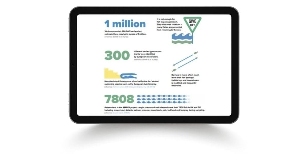
EU AMBER Project
Compass also contributes GIS expertise to the EU AMBER Project, an initiative focused on agri‑environment monitoring and biodiversity evaluation. By integrating soil attributes, land cover and yield information with environmental indicators, GIS workflows under AMBER help stakeholders to:
- Assess field‑level environmental pressures
- Correlate agronomic performance with ecological conditions
- Support evidence‑based decision‑making across landscapes
This work demonstrates how spatial tools can support compliance with environmental regulations while also enhancing agronomic planning.
Learn how the EU AMBER Project uses spatial analysis to bridge agriculture and environmental stewardship across member states.
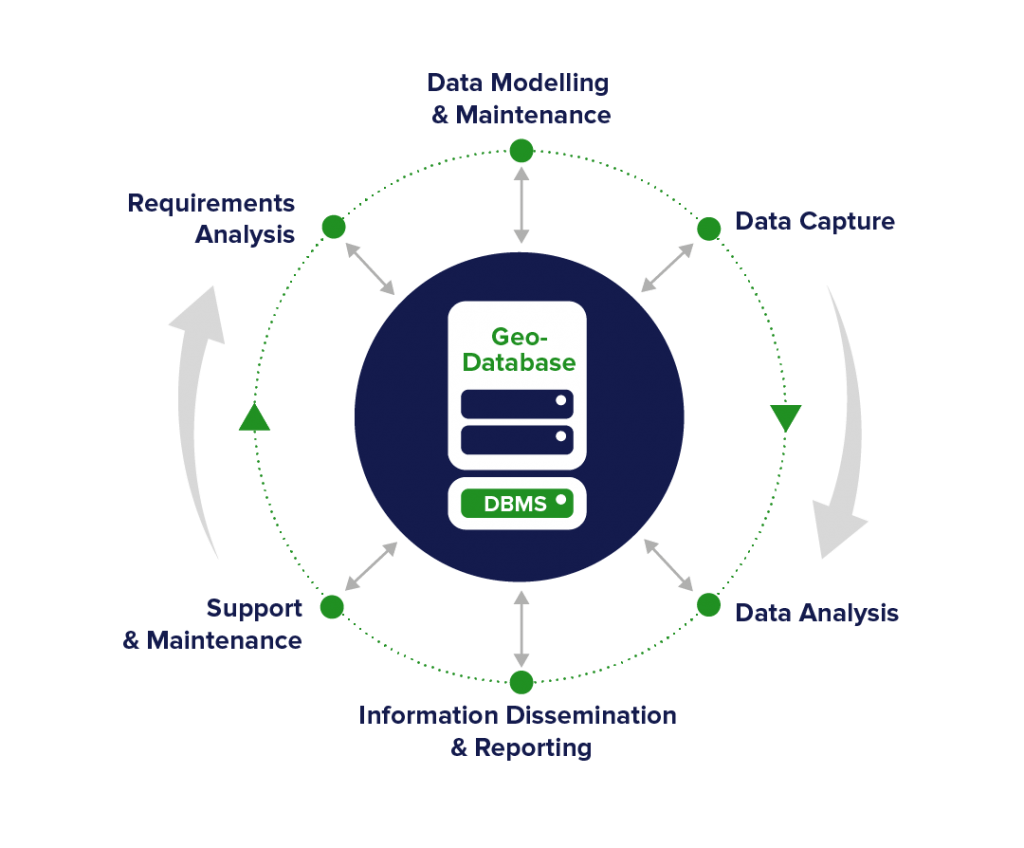
How Compass Builds Your Strategic Data Roadmap
Our approach begins with understanding not just your data, but your organisational goals:
-
Legacy Data Audit – Identify sources, quality and structure
-
Harmonisation & Integration – Build trusted, interoperable datasets
-
Spatial Modelling & Analysis – Generate actionable insight
-
Value Prioritisation – Determine data layers with highest strategic impact
-
Roadmap & Delivery Plan – Phased plan mapped to business outcomes
With GIS as the backbone of discovery, organisations can stop guessing and start knowing, what data matters, how it relates, and how it drives outcomes.
Your Data Is an Asset, Not a Burden
Whether you’re a regulator, a planner, an engineer or a service provider, legacy data holds insights that can shape your future. Compass Informatics turns that potential into reality by combining GIS, data analytics, and domain expertise to deliver tools and roadmaps that guide confident decision‑making.
Contact Compass Informatics today to discuss your data strategy and discover how mapping and analytics can unlock the power in your legacy data.